A New Dallas

Traffic
Four Blind Spots:
Fundamental Purpose of Transportation
Induced Demand
Reduced Demand of Density and Mode Choice
The Rise of the Internet
Four Outlets:
TxDOT’s primary goal is to move traffic. 160,000 vehicles per day move through and past downtown (approximately 75% are not entering from nor exiting to downtown) specifically because the corridor is built there.
Furthermore, the focus of study is specifically about corridor capacity not overall area network capacity nor other equally important considerations. It isn’t about quality of place, nor socio-economic resilience. TxDOT’s process doesn’t create highly livable, functionally efficient, desirable places.
4 Blind spots in traffic modeling
Fundamental Purpose of Transportation: The primary purpose of a city is to facilitate social and economic exchange. To paraphrase Lewis Mumford, this means to maximize the greatest amount and variety of goods and people in a given area while minimizing the cost and energy required to facilitate the exchange. This means minimizing infrastructure cost in relation to value gained as well as distance.
Transportation infrastructure drives real estate markets. And by doing so there is inherently lag time between the two finding equilibrium. While transportation planners sincerely believe they are meeting the needs of the market as it exists, they actually are transforming the market with their actions, moving goods and markets further and further apart, hastening the need for evermore infrastructure and the inevitable vehicular congestion.
Road networks are currently measured based on speed rather than expedience, convenience, or efficiency of infrastructure, invariably leading to ubiquitous highway construction and fragmented cities, and dispersed populations. This is a failure of transportation departments focused strictly on moving cars rather than connecting goods, people, skills, ideas, and labor in a functional, safe, and efficient manner.
Induced Demand: Braess’s paradox states that adding extra capacity to a network often reduces the overall performance of the network when entities selfishly choose their route. This is only exasperated in the road networks of cities when there is a lack of legitimate choice in mode or route. Furthermore, modern transportation design funnels traffic into expanded individual corridor capacity rather than overall network capacity.
New highway capacity doesn’t lead to less congestion but rather more. In fact, when highway capacity is expanded by 10%, empirical studies show an immediate jump in demand of 4%. Ultimately, all 10% of the additional capacity is filled back to the point of congestion within ten years. The reason is induced demand. And in terms of cities, this is because of the change to real estate markets exerted by the change in infrastructure design and capacity.
This dynamic has been explained by two separate studies from the University of Toronto and Brown University. The Toronto study showed a 1:1 relationship between highway capacity and Vehicle Miles Travelled (VMT). For example, if a city doubles highway capacity in twenty years the average person is driving twice the amount after those twenty years. The Brown University corroborated this dispersion of people showing an 18% population loss each time a city adds an intra-city highway through it. The infrastructure we build determines our behavior. The further apart we are from destinations; you have no choice but to drive.
Due to Induced Demand, all traffic modeling in the United Kingdom is now required to account for it mathematically. Coincidentally, they’ve stopped unnecessarily expanding roads.
Reduced Demand of Density and Mode Choice: Density adds diversity of choice in transportation options. It creates the necessary proximity for walkability as well as the tax base and ridership to support mass transit. Traffic demand models simply input the same factors based on land use regardless of context. This tells the planner how large a road has to be based on the amount of housing and businesses in the area effectively generating trips on that road.
However, this invariably leads to roads being designed and built overly large in the densest of areas, often at the expense of private property and existing buildings, many of which must be razed to make way for the expanded road. And if not, they simply emptied out because the larger road reduced demand for the building’s utilization. The terrible irony of downtown Dallas is that as the city built its tallest skyscrapers in downtown (from the 1950’s to the 1980’s), the infrastructure being built simultaneously was systematically stripping the demand for those buildings. The results were equal parts inevitable and tragic.
Based on client initiated studies of various projects around the DFW, mixed-use multi-family buildings were found to generate 20% less car trips in walkable suburban locations and 40% less trips in walkable urban locations. These reductions aren’t factored into our road designs, thus leading to overly wide roads and ultimately disinvestment and decay of our core cities. Aware of this phenomenon, the city of San Diego is currently studying metrics to ensure context is taken into account when planning and designing roads.
The Rise of the Internet: Cities are the product of the primary transportation technology of their time. Australian professor of urbanism and sustainability Peter Newman’s studies reveal that cities are always roughly 30 minutes wide. Historic cities were built compactly as they were designed primarily for walking. The rise of rail technology gave way to streetcar suburbs. And ultimately, cities built entirely for the car such as Sun Belt cities expanded wider and less dense than any ever before. Interestingly, this theory aligns with surveys showing a preferred commute time between home and work (regardless of transportation mode) of about 22-minutes. Enough time to focus or decompress, but not too close.
Today, that primary transportation technology is the internet. However, it will never replace the power and value of face to face interactions as originally feared. Instead, we’re reshaping the internet in the form of web 2.0 and whatever is beyond in order to improve cities and improve social and economic exchange.
The mobile web allows us to find and meet our friends, new businesses, and exchange ideas. Telecommuting allows interaction without the long trip, meaning less capacity on transportation infrastructure built for the long trip. Yet, it doesn’t replace the short trip. We still like to make those in order to have those face to face interactions that make us human and enrich our lives. Traffic modeling doesn’t take the rise of the internet into account and is thus antiquated.
4 “Outlets” for how the traffic is dispersed and congestion is ultimately lessened as proven by case studies
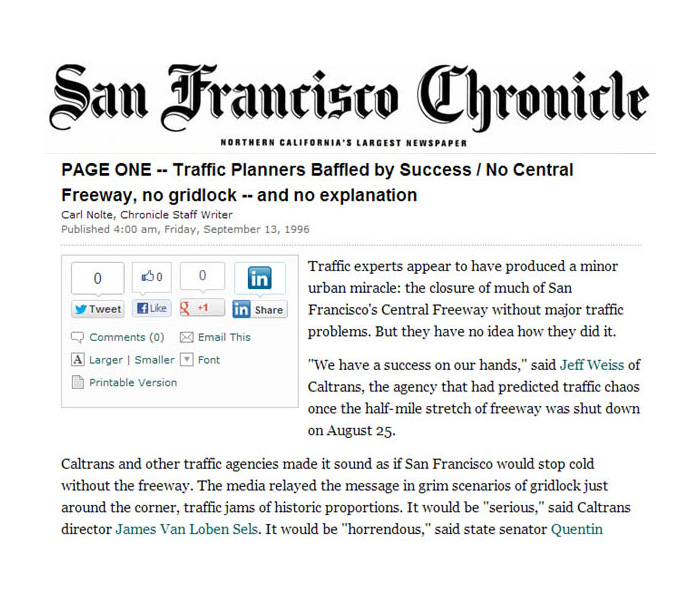
Regional: When the Westside Highway came down in Manhattan in the 1970’s, 53% of vehicular traffic disappeared. Similarly, when San Francisco tore down the Embarcadero and the Central Expressway traffic actually improved despite all of the dire warnings of chaos and “historic” levels of congestion. The reason is because much of this traffic isn’t actually going TO the city in question. It is simply cutting through because the road is there. In the case of New York, it was found that the mysterious disappearance of the cars was due to the majority of the users going from New Jersey back to New Jersey through Manhattan. Cutting through Manhattan was convenient for them. It wasn’t convenient for the residents that had to breathe the air or put up with the increased congestion.
Most highway traffic isn’t local. It is going from large areas to other large areas far away, which could easily bypass the city in similar amount of time due to the rush hour traffic in and around downtown. This is why we have loop 12, 635, and 190, to keep truck traffic away from the core functions of the city. If it isn’t going TO downtown, the traffic shouldn’t be IN downtown, polluting the air, congesting the roads, and endangering the roads.
Local: Jane Jacobs wrote that we need small infrastructure to reach our daily destinations, where we live, where we work, where we shop, as opposed to large infrastructure for longer trips, like to Fort Worth or Houston. Inter-city Interstate highways (like I-30 or I-45) work great for those trips. However, the presence of the intra-city highways (which Eisenhower opposed) pulls the traffic away from the historic street grid, sucking the life from the neighborhoods, thus making it impossible to have complete neighborhoods where you can walk to all of your daily needs if you so choose. The city’s network capacity was effectively reduced as we expanded intra-city highway corridor capacity.
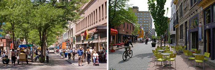
We shouldn’t fear traffic. Instead, we must diffuse, discipline, and diversify it into a choice of convenient modes. Focusing on corridor capacity concentrates vehicular traffic to the point of it being detrimental. When traffic is properly diffused and disciplined, traffic should equal value. It takes a grid of highly interconnected streets to do that. In downtown Vancouver, where highways have been prohibited since the 1960’s, the grid of streets handles twice the capacity of the highways that were proposed.
Near East Dallas Grid is 252,000 cars per day under its built capacity
Peak Avenue today
Unfortunately, the historic grid of East Dallas is woefully under capacity. The sum of primary arterial roads in the area currently operates 252,000 cars per day under the capacity they are built for. Many of these roads individually only move a few thousand cars per day despite being built to handle 20- or 30,000. Since businesses look at traffic counts when siting their businesses, areas that don’t have enough traffic, not enough life and vitality, disinvestment and decay is inevitable. Paradoxically, INCREASING traffic in East Dallas, provided it is traffic calmed and diversified, will actually help revitalize all of East Dallas.
Short-term: Author of the book Traffic, Tom Vanderbilt said, “traffic ‘cures’ are like hangover cures. They’re temporary, illusory, and don’t address the root problem.” Each time a highway has been torn out of the core of a city, surprisingly (to traffic planners) congestion actually dropped. Roughly, 75% of the traffic simply re-routes. It takes other roads or other highways. The other 25% disappears. It takes transit. It carpools. It telecommutes. It could be doing a variety of things, but what we know for sure, it is no longer needing nor using the highway. This is like reversing Induced Demand. If you remove capacity, you reduce some of the demand.
Long-term: The ultimate goal is density through desirability, the simple amenity of proximity TO amenity, re-stabilizing the equilibrium between tax base (population) and the infrastructure (cost) supporting its needs for social and economic exchange. Grids of safe, attractive, walkable streets are the optimal meeting place for such exchange.
 By replacing the repellant nature of a highway with a more attractive street and block structure and its immediate proximity to downtown, jobs, and amenities, Dallas could attract investment and population. The study area can support 25,000 new residents (and 50,000 less commutes) no longer needing highways to get to or from work. Instead, they could walk, bike, dart, drive on safer city streets, or even take a modern streetcar, paid for by this very investment.